Overview
Service Pack 6 of version 7.1, includes a number of enhancements to the GIS interface, as well as bug fixes and general improvements to the application platform.
Supported Third Party Applications and Versions
.Supported Platforms and Third Party Applications for Version 7.1 SP6 v7.1
New Features and Enhancements
- Added the ability to export a map layer as a shapefile
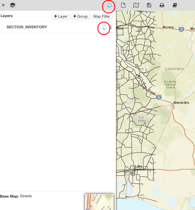
- Added a spinner to indicate when a layer added to a map or an opened map is still loading features
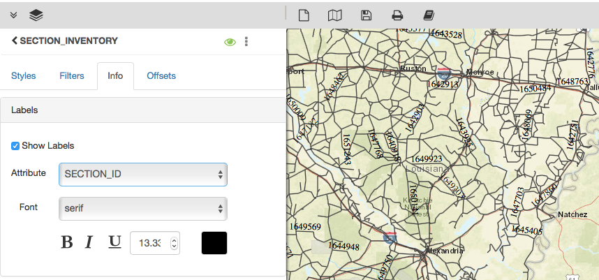
- Added the ability to change the font, size and color of attribute labels on a map layer
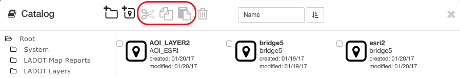
- Added the ability to cut|copy|paste items in the maps/layers catalog

Dropped/Replaced Features
- The built-in spell checker in the application has been dropped, in place of the spell checker in the web browser housing the application
Bug Fixes and Other Improvements
- Added: In the Roads & Highways Interface, a configurable timeout setting for the execution of the interface jobs
- Added: The CBC Solver (optimization engine for analysis) now supports the AgileAssets platform supported versions of RHEL
- Fixed: The login and logout options have been renamed to Log In and Log Out
- Fixed: Issue in the GIS Explorer, where attribute labels on a layer when enabled were not saved with a layer or newly created map with the layer
- Fixed: Issue in the GIS Explorer for IE 11, where text entered into text fields in the print panel could not be highlighted
- Fixed: Issue in Fleet Management, where material costs were not being split evenly across associated multiple vehicle repair orders
- Fixed: Issue in Maintenance Management, where an attempt to insert a material estimate on the Force Accounts screen resulted in an error
- Fixed: Issue in Bridge Management, where an attempt to submit a bridge inspection to quality control, results in an error
- Fixed: Issue in Bridge Management, where attachments could be added to a structure with an inspection status of 'On going Consultant Check'
- Fixed: Issue in Materials, where the total cost and date are not updated as a result of a correction from an inventory reconciliation
- Fixed: Issue in Pavement Management, where the contracts history breakdown incorrectly shows a gap in sections where one shouldn't exist
- Fixed: Issue in Jasper Reports, where a script error notification is displayed for some reports when attempt to retrieve/show a pdf report
- Fixed: Issue in Reports, where users belonging to a security profile assigned to some dashboards could not view those assigned dashboards
- Fixed: Issue where field labels in some windows and dialogs overlapped with their values or with other field labels
- Fixed: Issue where an error is displayed when attempt to apply a custom CSS to hidden fields in a window
Known Issues, Limitations & Restrictions
- The new GIS Interface like all web mapping applications requires datasets in the geographic coordinate system (EPSG:4326), so customer schemas with data stored in a different coordinate system would need to be transformed in order for map layers to be created from the dataset.
- Inserting a location or inventory item from a map is not functional when using Firefox as your web browser. To work around this limitation, use the other supported web browsers: IE 11, Chrome or Safari
- When select to print a map as an image (png file) whilst using Firefox as your web browser, the file is downloaded as map.png.pdf. You would have to manually edit out the '.pdf' extension from the file name, after the file has been downloaded, to be able to open/utilize the file
- While working on the GIS Interface and performing tasks that does not generate a request to the server (such as styling a map), your user session may expire as a result. The configured session expiration warnings will be displayed when this occurs or your session may timeout and a session expiration notification displayed, if a warning is not configured
- Map filter value does not get pre-populated in the Jasper report print template, even though the parameter is specified for display in the template
- Map filter value cannot be defined or edited for a map with a specified area of interest. To work around the definition limitation, the map filter should be defined before the AOI is set
- When labels are enabled and defined for a map/layer, the selection is not retained with the resulting map when the map is saved
- An area of interest filter and the crop setting are lost for a map when the screen is refreshed or across more than one user session
- A map's layer style settings become null and uneditable, when an applied filter is partially applicable or not applicable to the defined styling attribute values for the map
- On a map bound to a data window, some items when selected on the map aren't highlighted in the data window because they aren't present there (In data window items can be Access Regulated), but on the map all inventories are displayed.
- The loading and display of maps and associated styles in IE 11 is not as performant as Chrome, Firefox and Safari
- In the Roads & Highways interface, routes with curves are not handled properly by the ESRI FDGB API. A workaround is to have the agency densify the routes to turn the curves into line strings
- The HTML5 based copy/paste functionality has limitations on the number of rows that can be copied to a browsers clipboard
- IE 11 - 4000 rows
- Edge - 4000 rows
- Chrome - 400 rows
- Firefox - 1000 rows
- The spinner indicating that a layer is loading in the GIS Explorer, continues to spin after selecting to remove a previous loading layer by using either the new map or remove layer option